|
Forming a Grid
As mentioned earlier, longitude lines (meridians) are
also used to pinpoint locations on a map or globe. Don’t forget that
the main longitude line, the prime meridian,
serves as a starting point for numbering degrees east and west. Also,
the main latitude line, the equator, serves
as a starting point for numbering degrees north and south.
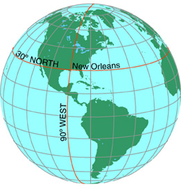
When latitude and longitude lines cross, they form a
set of intersecting lines known as a grid.
Using the grid of crisscrossing latitude and longitude lines, it is possible
to determine a location’s coordinates,
or its location measured by latitude and longitude.
|

|

